Showing posts with label sunset. Show all posts

March 31, 2013

Lahaina Sunset...

I always love a good sunset, and I'm afforded with many living in Hawai'i.  In this blog I'm standing on Launiupoko Beach, which is close to Lahaina on Maui's western shore.  If you've been to Maui, then you are probably familiar with Lahaina since it is Maui's most touristy town.  The island in the background is the Lana'i.  I have not yet been to Lana'i, but I'll make it there eventually.

Quick facts about Lana'i:
-6th largest Hawaiian island with a total of 140 square miles.
-Smallest Hawaiian island that is publicly accessible (plane flight or ferry from Maui)
-Has only one school (K-12)
-No stop lights exist on the island
-Population of approximately 3,000 people
-It's known as the Pineapple Island, because James Dole (of the Dole Food Company) bought the island in 1922, and made most of the island into a Pineapple plantation.

Still a little bit before sunset

Below are two similar pictures taken a few minutes apart, so I made one into a black and white.


Lots of great golds and blues as the sun descends towards Lana'i.

Just a spec of sun left.

Well, the history with the ocean and my slippers continues.  While I was taking the pictures above I left my slippers behind on the beach.  It was windy and when I came back both of my slippers were gone.  I caught one 40 meters away, just before it went into the ocean.  I'm assuming the ocean swallowed the right one.  So it was off to the drug store to buy another pair.  I guess it's good they cost less than 5 dollars.  So I walked into the drug store slipperless, cut the tags off at the register, paid and then chucked the leftover slipper in the cashier's rubbish can...the cashier laughed at me when I explained that this was not the first time I've had to do this.  For the record it's Pacific Ocean: 2,  Hawai'i Topher: 0.

March 2, 2013

Road to Hana, part 2...

Continued from Road to Hana, part 1...  If you have not seen the first part then click here to see it first.  Then it will bring you back to this blog posting.


Well, I'm now sulking after a tough loss where my Cats got manhandled at Arkansas.  They just didn't prove to be very tough today.  I mean, holy turnovers Cats!  That had to be the most turnovers we've had under Cal.  I had higher expectations for today after our last two quality wins despite our best player obtaining a season ending injury.  Head high, regroup and continue on.  I digress...

After my Dad and I left Hana and continued around Haleakala (the Eastern Maui Volcano), the sky finally started to open up.  It was fascinating since we were driving along the rain could's edge.  The slope of Haleakala is very gradual, so you can never really see the towering peak, which is above the clouds anyway.  It's a gradual slop that eventually drops into the ocean.


The water in the next picture was the coolest I have ever seen.  The wind was gusting above 30 mph, and was blowing across the water perpendicular to the inland swells.  This action gave it an interesting texture, and you can see the criss-cross pattern in the picture below.  It was fascinating to see it move.  The rain cloud edge and blue sky beyond it gave a nice effect too.


Little rainbows kept popping up as the edge of the rain cloud kept moving back and forth over us.
Finally some sun after raining all day.  Most of the day, I felt like I was back in NKY in early April.
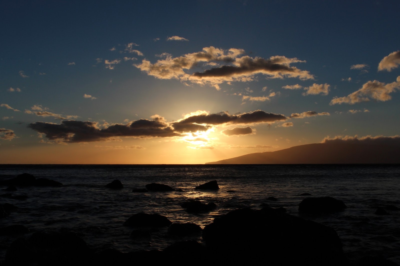
The sky opened up just in time for Dadster and I to see the best sunset ever (and I can judge...I see a lot of sunsets living here).  The red color bouncing off the dark rain cloud was something I've never seen before.  

Picture with the sun still hitting the backside of the rain cloud. 
The island you see in the distance is Kaho'Olawe (you might have to pull the picture up to full size by clicking on it).  Kaho'Olawe is the smallest of the 8 primary Hawaiian islands.  It is 7 miles off the Maui coastline and is 11 miles long by 6 miles wide.  It has a total of 45 square miles.  No one lives on the island, since it's currently being restored.  Why is it being restored you ask?  Well sure, Professor Topher will make an appearance...

History lesson (nerd alert): After the Japanese raid on Pearl Harbor, the U.S. Military declared martial law in Hawai'i, and ceased loads of land across all the islands, including the entirety of Kaho'Olawe.  This particular island was very important to the U.S. Military, because it set the tone for how the U.S. Navy would succeed in the Pacific during the war.  Unfortunately, the land was really important to the Hawaiians too: it was sacred land to them, and people did live there at the time.  The Military practiced raiding the shore here to learn the best methods before they island hopped all over the Pacific, but mostly they used the land for airborne bombing practice, surveillance training and munition testing.  One time the Navy wondered how far ships would have to be anchored out to sea to be unharmed from a large land based explosion.  So they parked a couple big Navy ships a mile offshore and then several others of varying distances past that.  Then they blew up 500 tons of TNT on shore.  Long story short: the ships need to be a lot further away than a mile!  But think of what happened to the island when they did that.  They military gave most post-WWII-ceased land back shortly after the WWII, but not Kaho'Olawe.  They continued to use it for munitions testing and bombing drills during the Korean War, Vietnam War and even the Cold War.  President Bush signed an order in 1990 to cease testing there and return the land to the state of Hawai'i.  The Military started cleanup (which they are still doing) and complied in 1994...after it had be decimated with 50 straight years worth of bombings.

One of the doctors I work closely with is Hawaiian, and she belongs to a conservation group that visits Kaho'Olawe as part of the restoration.  She travels there a few times a year to plant grasses and other bushes.  She was really excited after returning a few months ago, stating a few grasses were finally taking seed, so they are hoping to plant some tree saplings in a year or two...it'll be a looooong process.  In fact, she can only go to a small portion of the island because the U.S. Military is still cleaning up unexploded munitions.  My understanding is that the Military isn't being extremely slow about it (since it's been 23 years of cleanup), but that there really is a lot of explosive material still litered across the island.  OK, I'll stop the history lesson now, but if you want to read more about Kaho'Olawe, then here's a case study or you can google it.

Here's one last picture a couple minutes after the previous one.  The sun has set all the way, so it isn't hitting the rain cloud any longer, but you can see Kaho'Olawe a little bit easier just past the fence.

Mahalo for visiting!

January 15, 2013

Sailing...

While Dad, Beth and Laura were in town for Christmas we went on a catamaran sail at sunset.  We celebrated Daddio's birthday the same day.  Happy Birthday Pops!  This trip was also my first whale sighting here in Hawaii.  The Humpback Whales are arriving more and more by the day.  They vacation in Hawai'i's winter waters to rear their newly born calves.  They make the journey from the northern arctic waters.  The easiest way to spot them is by the water spouts on the horizon and then look in those areas.  I did manage to get a picture of a tail (below).  The pictures pretty much speak for themselves, so mahalo for visiting and enjoy!


Whale spout and whale tail!


Our ride for the evening.

May 7, 2012

Super Moon Night!

Saturday evening was the Super Moon for 2012.  In case you don't know what that means: its a full moon during the calendar year of 2012 that is closest to Earth (when compared to the other full moons of 2012).  The full moon this year was 15,400 miles closer than its typical average.  So the moon appeared brighter and 14% larger.  The moon pictures are after the following set (while waiting for the sun to set I was just playing at the beach).

Smess this pictures is just for you since you like pictures "with multiple depths."  
I took about 30 pictures to get this one shot just for you.
T3i: SS 1/500, f 4.5, ISO 100, FL 18.0
T3i: SS 1/320, f 5.0, ISO 100, FL 18.0
T3i: SS 1/320, f 5.6, ISO 100, FL 50.0
Thanks to Sends and his constructive criticism, my new and improved camera settings allowed me to get the next shot!  The sun was actually already fully set when I snapped this picture.  Crazy right?  Not really sure how I managed it.  This shows the Waikiki Beach Hotel Strip.
T3i: SS 1/20, f 4.0, ISO 200, FL 20.0
T3i: SS 1/50, f 4.0, ISO 200, FL 24.0
T3i: SS 1/50, f 4.0, ISO 400, FL 18.0
T3i: SS 0.60, f 4.0, ISO 1600, FL 18.0 
T3i: SS 0.8, f 4.0, ISO 1600, FL 22.0
T3i: SS 1.3, f 5.6, ISO 800, FL 55.0
The Super Moon looks like its rising right out of Diamond Head Crater.

T3i: SS 0.6, f 5.6 ISO 3200, FL 18.0
Shortly after the moon started to rise over Diamond Head, I realized there was too much light around Kapiolani Park, so I headed to a lookout at Diamond Head, which turned out to be ideal.  I was able to get away from the other lights, and it also afforded a view of the moon reflecting off the ocean by the seaside neighborhood of Kahala.  (tip: click on the pictures below so it magnifies them otherwise they are hard to see since the frame is dark compared to the blog's bright background)

T3i: SS 1/6, f 3.5, ISO 3200, FL 18.0
T3i: SS 0.5, f 5.6, ISO 800, FL 55.0
T3i: SS 0.6, f 4.0, ISO 800, FL 27.0
T3i: SS 0.8, f 4.5, ISO 800, FL 34.0
T3i: SS 1.3, f 4.5, ISO 400, FL 26.0
T3i: SS 0.8, f 4.0, ISO 400, FL 28.0
Thanks for visiting.  If you are reading this last little part then you should leave me a comment below.  I know plenty of people are reading but its great to hear from you.  (and if you have a nickname that you go by AND that I know then leave it written too....my niece likes to try and guess who it is that is leaving the post despite not knowing nicknames.  Moose: you are the only one she didn't get so far.)