March 31, 2013

Lahaina Sunset...

I always love a good sunset, and I'm afforded with many living in Hawai'i.  In this blog I'm standing on Launiupoko Beach, which is close to Lahaina on Maui's western shore.  If you've been to Maui, then you are probably familiar with Lahaina since it is Maui's most touristy town.  The island in the background is the Lana'i.  I have not yet been to Lana'i, but I'll make it there eventually.

Quick facts about Lana'i:
-6th largest Hawaiian island with a total of 140 square miles.
-Smallest Hawaiian island that is publicly accessible (plane flight or ferry from Maui)
-Has only one school (K-12)
-No stop lights exist on the island
-Population of approximately 3,000 people
-It's known as the Pineapple Island, because James Dole (of the Dole Food Company) bought the island in 1922, and made most of the island into a Pineapple plantation.

Still a little bit before sunset

Below are two similar pictures taken a few minutes apart, so I made one into a black and white.


Lots of great golds and blues as the sun descends towards Lana'i.

Just a spec of sun left.

Well, the history with the ocean and my slippers continues.  While I was taking the pictures above I left my slippers behind on the beach.  It was windy and when I came back both of my slippers were gone.  I caught one 40 meters away, just before it went into the ocean.  I'm assuming the ocean swallowed the right one.  So it was off to the drug store to buy another pair.  I guess it's good they cost less than 5 dollars.  So I walked into the drug store slipperless, cut the tags off at the register, paid and then chucked the leftover slipper in the cashier's rubbish can...the cashier laughed at me when I explained that this was not the first time I've had to do this.  For the record it's Pacific Ocean: 2,  Hawai'i Topher: 0.

March 14, 2013

Sugar Beach...

Nothing too special about this post.  Just a beach in Maui, aptly named Sugar Beach, since it is surrounded by sugar cane fields.  Sugar Beach has a nature conservatory and board walk too.  If you are a regular visitor to my blog, then hopefully you've been enjoying my visit around Maui.  As always, much Mahalo for taking some time to see what I've been up to.  I wish you a great day!  (and go Wildcats as they start their SEC journey!)

The boardwalk's bridge.

The trees and grasses between the boardwalk and beach were arid and dry plant species.  At first glance they often seemed dead, but that's how they are supposed to look I guess.
A couple of birds doing their best flamingo impersonation.
I have no idea what these were supposed to be, but there were several of them on the beach.
Haleakala is chilling above the clouds in the distance.
You can see several windmills along the far ridge.

Mahalo!

March 9, 2013

Zip-lining Across Maui...

Super pumped today.  My Wildcats got a big win today.  Of course, it happened when I didn't watch the game: the first time all year where I didn't watch (or delay watch) it.  But that's OK...maybe I should stop watching.  We were in the bubble, then our bubble popped, and now we're firmly back in the bubble!  Come on UK!  OK, moving on...

Pops and Topher
Our last day in Maui we finally went zip lining.  The weather had been questionable, as mentioned in previous posts.  We were on the west side of Maui and basically just zipped from one ridge to the next along the mountain.  In all, we zipped 2.5 miles along the ridges.  One line was 3/4 of a mile long and was awesome.  That line was a long ride, and very thrilling since we reached approximate speeds of 60 mph.

The views were great.  From the eastern ridges of west maui were could look over Maui's middle plains of sugar cane crops and see Haleakala in the distance.  I had my iPhone in tow and even took a video, which is at the bottom.

I'm up next at the training line.
Some of the ridges we were zip lining over.

Sugar cane is the all the green in this photo.  Haleakala in the far distance.
The edge of Haleakala (upper left).  Sugar cane fields (middle left).  Maalaea Bay (middle).
Our next zip line to travel (far right)

This is a picture I took later in the day.  We were zip lining on the mountain in this picture from ridge to ridge.
In the video below, it shows Dadster coming into one of the landing decks.  He is only a spec in the video until he comes into the braking blocks.  Oh and one more tip: turn your sound off/down before you push play.  The wind makes the video really loud and there's really not much to hear anyway.


Mahalo for visiting!

March 6, 2013

Broken Bones and Biking...

Wow, just thinking back to this particular excursion reminds me of how crazy it was.  Dad and I had made reservations to bike down Haleakala Volcano.  We woke up at 2:45 am since we had to be at the bike rental shop at 3:30am to get outfitted and start the journey up the volcano.  We were planning on seeing the sunrise from on top the volcano, and then bicycle 25 miles back down.  I was really excited about this, but the excitement was on the inside because I'm sure my appearance on the outside displayed the opposite this early in the morning.

Before I talk about my experience, how about some facts about Haleakala:
-Haleakala in the Hawaiian language means house of the sun.
-The summit is 10,000 feet above sea level
-It's a shield volcano that created 75% of the island of Maui (also know as the East Maui Volcano).
-Haleakala crater is at the top; it and the surrounding area is designated as a National Park.
-Haleakala crater was one of the first national parks and was designated as such less than a week after the creation of the U.S. National Park System in 1916 under the Dept. of the Interior.
-Haleakala is technically an active volcano, but is not currently flowing and shows no signs to doing so in the near future.
-The last lava flow there was 350-500 years ago.

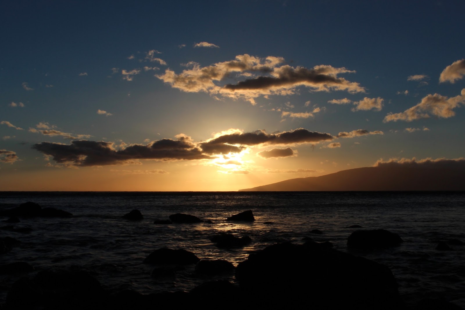
A view of Haleakala from the east side of the island (across the bay).


OK, now onto my trip.  We headed up the volcano in a van full of our gear.  At the summit it had temperatures in the 30's with wind gusts into the 40+ mph range pushing 'feels-like' temps into the teens.  So in other words: it was freezing up there when I'm used to 75-85 degree temps; plus it was raining!  Unfortunately, mother nature didn't cooperate with us and we didn't get to see the Sunrise.  We did get to see the sun shortly after it rose (see picture to the right).  Haleakala is called the house of the sun for a reason because it's supposed to be breathtakingly amazing.  The area is sacred ground to the ancient Hawaiians.  After we found a little bit of sunlight, we loaded back into the van to exit the main park area where we'd start our bikes.  They used to start the bike ride at the very top, but there there were a couple fatal accidents, so the National Park Service makes the companies start outside the park area.  Fatal accidents?  We later found out just how dangerous it is...

High above the clouds.

This picture courtsey of Dad.  The outfitter for our trip told us the little cloud rainbows are called Rainbow Dogs, but he was rarely truthful about anything so I'm not sure if he was telling us the truth or not???
Now it was time to get on our bikes.  We were at 9000 feet to start.  We unloaded the gear, and strapped on our helmets.  The winds were gusting hard, and this was where the trip became interesting.  A trailer door blew over so hard it knocked 2 people to the ground as we were unloading gear.  Dad and I were ready, and it was a self guided tour (where we just returned the bikes when we returned to the shop 25 miles later), so were off.  Dad started and I said I'd follow, but as I was getting on my bike an Australian tourist was telling me he couldn't move his arm (he took the blunt of the blow from the trailer door) and his arm appeared dislocated.  I yelled to Dad to stop, but with the wind he couldn't hear me and continued on, but I stopped to help.  The Outfitter and I got him back on the bus and took his jacket off.  Fortunately, his shoulder wasn't dislocated.  His elbow, however, was already swollen and awkwardly positioned.  While I was assess it, I asked "Does it hurt really bad right here?", he replied with (and imagine a painful, loud, Australian accent with the next statement): "Yes, it bloody hurts mate!"  Pretty sure he had a proximal ulna fracture (ie. just below the elbow).  As I was putting Mr. Australia in a triangle sling a call came over the van's radio about a bicycle wreck involving an older man a half mile down the road.  My first thought: Oh no, Dad is a half mile down the road by now!  So now I'm jumping out the van door, donning my helmet and jumping on my bike.  The wind was literally blowing me off the road and I almost crashed a couple times on my way as I navigated the switchbacks and shifting wind patterns.

I caught up to Dad at the accident site, and was happy to realize he was fine.  Dad held my bike as I went to investigate.  This person had been biking like us, but with a different company.  Sure enough, it was serious.  The man had an open fracture of the femur (ie. his lateral thigh had a bone sticking out of it...it was pretty awesome in hindsight).  All things considered, his vitals appeared OK, but he was not very responsive and had a deer-in-the-headlights look.  It was still windy and cold.  A family member had covered him with their clothes and was doing their best to block the wind by laying next to him, trying to stave off shock.  Another tourist, who was driving by, stopped her car in the road to block traffic and luckily, she was a nurse.  She said she'd monitor vitals until the ambulance arrived.  Thankfully, the ambulance arrived a short time later.

At this point I felt like I was working ER triage versus biking down a mountain while on vacation.  Dad and I continued on and then we had fun (and managed to survive).  The views were awesome as we descended through the cloud level.


A few miles into the trip we finally reach the tree line.  It had been mostly baren at the higher elevations.  The blue spec on the road in the picture below is Dad.  He's one switchback ahead of me, and two switchbacks away from the tree line.  In the distance (slightly to the right) you can see the West Maui Volcano, and in the far distance (middle of picture) you can spot the island of Lana'i just under the cloud.


Switchback here I come!

We stopped at the tree line to take a break.  Granted we were going downhill so it should have been easy, but it was a little tiresome (physically and mentally) to constantly focus on not being blown over the guardrail and navigating the challenging switchbacks.  The trees brought welcomed relief from the relentless winds.
We stopped half way at a local breakfast spot.  The strawberry cream waffles were awesome.

near the bottom view of Iao Vally (the cut in the mountains) along the West Maui Volcano.
We got a little lost while it was raining toward the end of the trip but it was fun overall.

Mahalo for visiting.

March 2, 2013

Road to Hana, part 2...

Continued from Road to Hana, part 1...  If you have not seen the first part then click here to see it first.  Then it will bring you back to this blog posting.


Well, I'm now sulking after a tough loss where my Cats got manhandled at Arkansas.  They just didn't prove to be very tough today.  I mean, holy turnovers Cats!  That had to be the most turnovers we've had under Cal.  I had higher expectations for today after our last two quality wins despite our best player obtaining a season ending injury.  Head high, regroup and continue on.  I digress...

After my Dad and I left Hana and continued around Haleakala (the Eastern Maui Volcano), the sky finally started to open up.  It was fascinating since we were driving along the rain could's edge.  The slope of Haleakala is very gradual, so you can never really see the towering peak, which is above the clouds anyway.  It's a gradual slop that eventually drops into the ocean.


The water in the next picture was the coolest I have ever seen.  The wind was gusting above 30 mph, and was blowing across the water perpendicular to the inland swells.  This action gave it an interesting texture, and you can see the criss-cross pattern in the picture below.  It was fascinating to see it move.  The rain cloud edge and blue sky beyond it gave a nice effect too.


Little rainbows kept popping up as the edge of the rain cloud kept moving back and forth over us.
Finally some sun after raining all day.  Most of the day, I felt like I was back in NKY in early April.
The sky opened up just in time for Dadster and I to see the best sunset ever (and I can judge...I see a lot of sunsets living here).  The red color bouncing off the dark rain cloud was something I've never seen before.  

Picture with the sun still hitting the backside of the rain cloud. 
The island you see in the distance is Kaho'Olawe (you might have to pull the picture up to full size by clicking on it).  Kaho'Olawe is the smallest of the 8 primary Hawaiian islands.  It is 7 miles off the Maui coastline and is 11 miles long by 6 miles wide.  It has a total of 45 square miles.  No one lives on the island, since it's currently being restored.  Why is it being restored you ask?  Well sure, Professor Topher will make an appearance...

History lesson (nerd alert): After the Japanese raid on Pearl Harbor, the U.S. Military declared martial law in Hawai'i, and ceased loads of land across all the islands, including the entirety of Kaho'Olawe.  This particular island was very important to the U.S. Military, because it set the tone for how the U.S. Navy would succeed in the Pacific during the war.  Unfortunately, the land was really important to the Hawaiians too: it was sacred land to them, and people did live there at the time.  The Military practiced raiding the shore here to learn the best methods before they island hopped all over the Pacific, but mostly they used the land for airborne bombing practice, surveillance training and munition testing.  One time the Navy wondered how far ships would have to be anchored out to sea to be unharmed from a large land based explosion.  So they parked a couple big Navy ships a mile offshore and then several others of varying distances past that.  Then they blew up 500 tons of TNT on shore.  Long story short: the ships need to be a lot further away than a mile!  But think of what happened to the island when they did that.  They military gave most post-WWII-ceased land back shortly after the WWII, but not Kaho'Olawe.  They continued to use it for munitions testing and bombing drills during the Korean War, Vietnam War and even the Cold War.  President Bush signed an order in 1990 to cease testing there and return the land to the state of Hawai'i.  The Military started cleanup (which they are still doing) and complied in 1994...after it had be decimated with 50 straight years worth of bombings.

One of the doctors I work closely with is Hawaiian, and she belongs to a conservation group that visits Kaho'Olawe as part of the restoration.  She travels there a few times a year to plant grasses and other bushes.  She was really excited after returning a few months ago, stating a few grasses were finally taking seed, so they are hoping to plant some tree saplings in a year or two...it'll be a looooong process.  In fact, she can only go to a small portion of the island because the U.S. Military is still cleaning up unexploded munitions.  My understanding is that the Military isn't being extremely slow about it (since it's been 23 years of cleanup), but that there really is a lot of explosive material still litered across the island.  OK, I'll stop the history lesson now, but if you want to read more about Kaho'Olawe, then here's a case study or you can google it.

Here's one last picture a couple minutes after the previous one.  The sun has set all the way, so it isn't hitting the rain cloud any longer, but you can see Kaho'Olawe a little bit easier just past the fence.

Mahalo for visiting!

March 1, 2013

Road to Hana, part 1...

OK, OK, I'm sorry.  Several family and friends have called me out for hardly posting anything over the past month as well as doing a poor job of keeping in touch.  Well, I have plenty of things to post about, so look out.  March will contain a lot of posts since I've been busy exploring several islands and have had some great times with family and friends visiting Hawai'i.  Friendly reminder: you can subscribe in the upper right part of the webpage and it'll email you when a new one is up.  Onto the blog:

iPhone Rainbow
In January, my Dad was still in town visiting after the holidays.  We hopped over to Maui to visit for an extended weekend.  There are several adventurous things to do in Maui, and neither of us ever turn down excitement.  Up first was zip-lining!  Unfortunately, I received a call a couple minutes after getting off the plane telling us our reservations were rescheduled for a different day due to severe winds.  Humph!  The strong winds and driving rain that greeted us as we de-boarded the plane did provide one of the most vibrant rainbows I've ever seen (and I'm spoiled because I see a lot of rainbows...so me vouching for this rainbow says a lot!).  Plus it was a double rainbow.

We had planned on organizing the rest of our Maui vacation after we went zip-lining, so now we needed a quick plan B.  We had the whole day free so we decided to do the famous Road to Hana trip.

First, a few facts about Maui:
-Nickname is the Magic Isle.
-Second largest Hawaiian island.
-Population of about 150,000 people, which means it is not very populated.  Tourist tend to go here when they want to "get-away."  Reference: Honolulu (on O'ahu) has about a million people.
-Has many small little towns that are all spread apart from each other through out the island.
-The landscape is easiest to picture if you think of two huge hills (or volcanos) that are then connected in the middle.  Kind of like a 3-D figure 8, which the island sort of resembles on a map.  Hundreds of thousands of years ago the two hills/volcanos weren't connected, but have become connected due to erosion and run-off from the two volcanos settling between the two.
-Maui heavily exports sugar cane, and you see it anywhere there is flat land.
-Maui's main volcano, Haleakalais still considered an active volcano and last erupted about 350 years ago.  It has not shown any signs of potential eruptions, but is still considered active due to the timespan since the last eruption.  It's had many eruptions over the past 1000 years (apparently 350 years in volcano-time is like a minute in human time).

OK, more about Haleakala later.  Road to Hana time!  Hana is a quaint little town on the East side of the island.  To get to it you have to take the Hana Highway.  Travelling the Road to Hana is a popular tourist activity.  Hana is only 52 miles away, but the Hana Highway is 68 miles in length and takes 2.5 hours to travel (without stopping).  It has approximately 620 hairpin turns and frequent one lane stretches.  It has 59 bridges and 46 of those are one lane wide.  All but one of those bridges date back to the 1910's when the road was initially constructed (they just built stuff better back then!).  The road winds through tropical rainforest the entire way, and passes countless waterfalls.

Unfortunately mother nature was not very kind to us during the first half of the day.  It varied between sprinkling and pouring during our entire trip to Hana.  I constantly struggled to keep my camera lenses dry, and eventually I gave up, so I didn't take many pictures.  We did get to see countless waterfalls, and all the rain was making them very energetic.

Vally along the Hana Highway
Rainy day.  Overlooking some sugar cane fields and the ocean in the distance.
This was an awesome waterfall.  It actually expanded even more to the right, but this was as far back as I could get from it.
Just following the steps down into the hole.
As we got close to Hana we saw a sign for the world's largest lava tube.  I wasn't entirely sure what a lava tube was (other than an obvious guess that it wasn't just a clever name), so the Pops and I decided to check it out.  After all, a tube implied there would be some form of shelter from the rain...or so we thought: water dripped from the ceiling of the tube at such a constant rate that it still seemed like it was raining!

A lava tube is basically a cave that lava flowed through a long time ago.  The outer part of the lava cooled first creating natural pipes (the volcano's "plumbing" if you will).  When the hot lava flowed back into the earth it left behind a large underground tube/cave.

The lava tube was really neat.  It was pitch black except for our flashlights.  The lava rock had many colors in it too.  The entrance is nothing more than a hole in the ground where part of the lava tube's ceiling caved in.
Pictures are hard to take in the pitch black but here is one I took at the beginning.
Another waterfall along the Road to Hana.
Once at Hana, Daddy-cracker and I had some lunch at the beach park (it was still raining).  Now the typical tourist would then head back along the Hana Highway from whence we came, but I always like to pretend that I'm a local - a coworker of mine told me there was a road that continued on around the backside of the island in a loop and people don't often realize this.  I think there was a good reason for this: the road was even more terrible and treacherous than the Hana Highway.  Our Ford Focus screamed the whole way. Luckily it survived, because I found out later that rental cars are not allowed on that stretch of road (apparently there was a sign that states this, but we must have missed it...oops!).  Being the adrenaline seeker that I am, I thought the road was totally fun, but I'm not sure how much my Father enjoyed it from the passenger seat as we blindly careened around the sides of cliffs on a rocky road with potholes which were far deeper than the Focus' ground clearance (yikes!).

As we headed around the Southeastern side of the Haleakala (the East volcano on Maui), we started to get out of the rain and enter beautiful pastures that sloped all the way from the clouds on our Right down to the sea on our Left.  Dad and I were treated with some beautiful views along the way.  Here is one picture to peak your interest, but I'll throw in some more for my next blog: The Road to Hana, part 2... (link is below)


Mahalo for visiting!  Click on this link to go to Road to Hana, Part 2...